
Portal:Western Australia
Introduction
 Western Australia (commonly abbreviated as WA) is a state of Australia occupying the western third of the land area of Australia, excluding external territories. It is bounded by the Indian Ocean to the north and west, the Southern Ocean to the south, the Northern Territory to the north-east, and South Australia to the south-east. With a total land area of 2,527,013 square kilometres (975,685 sq mi), Western Australia is Australia's largest state as well as the second-largest subdivision of any country on Earth, surpassed only by the Sakha Republic in eastern Russia. the state has 2.76 million inhabitants—11 percent of the national total. The vast majority (92 percent) live in the south-west corner; 79 percent of the population lives in the Perth area, leaving the remainder of the state sparsely populated. The first Europeans to visit Western Australia belonged to the Dutch Dirk Hartog expedition, who visited the Western Australian coast in 1616. The first permanent European colony in what is today Western Australia occurred following the landing by Major Edmund Lockyer on 26 December 1826 of an expedition on behalf of the New South Wales colonial government. Lockyer established a convict-supported military garrison at King George III Sound, at present-day Albany, and on 21 January 1827 he formally took possession for the British Crown of the western part of the continent that was not already claimed by the Crown. This was followed by the establishment of the Swan River Colony in 1829, including the site of the present-day capital, Perth. (Full article...)
|


-8a.jpg)


.JPG)


(Northern
Territory) |
 Good articles -
-

Severe Tropical Cyclone Sam (JTWC designation: 03S) was an intense tropical cyclone that brought flooding rainfall to a wide swath of northern Australia in December 2000. The first tropical cyclone of the regional season, Sam originated from a tropical low that formed in the Arafura Sea on 28 November. Tracking generally westward, the initial low-pressure area remained generally weak until it entered the Timor Sea, by which time it had strengthened into a tropical cyclone on 5 December. Though a subtropical ridge was forcing the cyclone westward at the time, an approaching shortwave trough caused Sam to track southward the following day, towards the Australian coast. During its southward progression, Sam rapidly intensified, and reached its peak intensity on 8 December. Soon afterwards, the storm made landfall near Lagrange, Western Australia at the same intensity. Once inland, Sam was slow to weaken as it re-curved eastward, and persisted for nearly a week inland before dissipating on 14 December.
Throughout its existence, Cyclone Sam brought heavy rainfall to a wide swath of northern Australia. Rainfall peaked at 520 mm (20 in) in Shelamar over a 48-hour period ending on 11 December. Upon making landfall, damage was considerable, albeit localized. Most of the destruction wrought by Sam occurred near the coast, particularly in Bidyadanga and Anna Springs Station. Some buildings sustained considerable damage, and trees and power lines were felled, resulting in some power outages. Offshore, 163 illegal immigrants aboard two vessels were feared to have drowned, which would make Sam one of the deadliest cyclones in Australian history. However, these people were later accounted for. After the season, the name Sam was retired from the regional naming list. (Full article...) -
Carlisle railway station is a temporarily-closed suburban railway station on the Transperth network in Western Australia. It is in the Perth suburbs of Carlisle and East Victoria Park, and was predominantly served by Thornlie line services prior to its closure in November 2023.
The station first opened in July 1912. It was known as Mint Street station at first, but it was renamed Victoria Park East station in October 1912 and to its present name in May 1919. It gained a station master in 1922, which lasted until 1971. Carlisle station had minor upgrades from 2002 to 2003 in preparation for the opening of the Thornlie line, which happened in 2005. Since 20 November 2023, the station has been closed to undergo a complete rebuild as an elevated station as part of the Victoria Park-Canning Level Crossing Removal Project to remove a nearby level crossing. The station and line are planned to reopen in mid-2025. (Full article...) -
Great Northern Highway is an Australian highway that links Western Australia's capital city Perth with its northernmost port, Wyndham. With a length of almost 3,200 kilometres (2,000 mi), it is the longest highway in Australia, with the majority included as part of the Perth Darwin National Highway. The highway, which travels through remote areas of the state, is constructed as a sealed, predominantly two-lane single carriageway, but with some single-lane bridges in the Kimberley. Economically, it provides vital access through the Wheatbelt and Mid West to the resource-rich regions of the Pilbara and Kimberley. In these areas, the key industries of mining, agriculture and pastoral stations, and tourism are all dependent on the highway.
In Perth, the highway begins in Midland near Great Eastern Highway, and further north intersects the Reid and Roe highways, which together form Perth's ring road. There are also three rural highways that spur off Great Northern Highway. Brand Highway and North West Coastal Highway provide an alternative coastal route between Muchea and Port Hedland, while Victoria Highway carries the National Highway route and interstate traffic into the Northern Territory. Various road routes are allocated to sections of Great Northern Highway, including the Highway 1 routes National Route 1 and National Highway 1, as well as National Highway 95. (Full article...) -

Henry Daglish (18 November 1866 – 16 August 1920) was an Australian politician who was the sixth premier of Western Australia and the first from the Labor Party, serving from 10 August 1904 to 25 August 1905. Daglish was born in Ballarat, Victoria, and studied at the University of Melbourne. In 1882, he worked as a mechanical engineer but soon switched to working in the Victorian public service. He first stood for election in 1896 but failed to win the Victorian Legislative Assembly seat of Melbourne South. He then moved to Subiaco, Western Australia, where he found work as a chief clerk in the Western Australian Police Department. In 1900, Daglish was elected to the Subiaco Municipal Council and in April the following year, he was elected to the Western Australian Legislative Assembly as the member for the newly created seat of Subiaco, becoming one of six Labor members in the Western Australian Legislative Assembly. The party elected him as its whip, and he resigned from the Subiaco council on 1 May 1901. On 1 December 1902, Daglish was sworn in as mayor of Subiaco, having been elected the previous month.
In the 1904 state election, Labor won 22 of the Legislative Assembly's 50 seats, making it the party with the most seats. On 8 July 1904, the Labor Party caucus elected Daglish as the party's leader, and on 10 August, he successfully moved a motion of no confidence in the government of Walter James, who resigned as premier. Governor Frederick Bedford then swore in Daglish as premier of Western Australia, colonial treasurer and minister for education. His keynote speech on 23 August was poorly received; militant Labor supporters saw him as giving up on Labor policies. In parliament, Daglish struggled to achieve anything due to a hostile Legislative Council; his one major success was the passing of a new Public Service Act. In June 1905, a cabinet reshuffle decreased Daglish's popularity within the Labor Party but he defeated a motion of no confidence at a caucus meeting later that month. Daglish resigned as premier on 22 August 1905 when his plan to buy the Midland Railway Company for £1.5 million (equivalent to AU$126,500,000 in 2022) failed to pass through parliament. Hector Rason succeeded him as premier on 25 August. (Full article...) -
Albany Highway links Western Australia's capital city Perth with its oldest settlement, Albany, on the state's south coast. The 405-kilometre-long (252 mi) highway travels through the southern Wheatbelt and Great Southern regions, and is designated State Route 30 for most of its length. Outside of Perth the highway is predominately a sealed, single carriageway with regular overtaking lanes in some undulating areas. Albany Highway commences at The Causeway, a river crossing that connects to Perth's central business district. The highway heads south-east through Perth's metropolitan region, bypassed in part by Shepperton Road and Kenwick Link, and continues south-eastwards through to Albany. It intersects several major roads in Perth, including the Leach, Tonkin, Brookton, and South Western highways. The rural section of Albany Highway connects to important regional roads at the few towns and roadhouses along the route, including Coalfields Highway at Arthur River, Great Southern Highway at Cranbrook, and Muirs Highway at Mount Barker.
Prior to European settlement, the indigenous Noongar people had a considerable network of tracks, including a trade route between the areas now known as Perth and Albany. Construction of a road between Perth and Albany began soon after the naming of Albany in 1832, but progress was slow, with only 16 miles (26 km) completed by 1833. A monthly mail route which operated in the 1840s had such trouble with the journey that a new contractor was required each year, and from 1847 the mail route detoured via Bunbury. The introduction of convicts in 1850, and thus convict labour, allowed a road along the direct route to be fully constructed by 1863. (Full article...) -
The Causeway is an arterial traffic crossing in Perth, Western Australia, linking the inner-city suburbs of East Perth and Victoria Park. It is carried over the Swan River at the eastern end of Perth Water by two bridges on either side of Heirisson Island. The current Causeway is the third structure to have been built across the river at this point.
Originally the site of mudflats which restricted river navigation, the Colony Government constructed a causeway and bridge across the site. The project was first planned in 1834 and opened in 1843. When floods in 1862 almost destroyed it, the structure was rebuilt using convict labour, and raised to better withstand future floods. Governor John Hampton officially opened the new Causeway on 12 November 1867. Over the following decades, the three bridges making up this second Causeway were widened several times, and they were eventually replaced in 1952. (Full article...) -
Council House is a 13-storey office building on St Georges Terrace in Perth, Western Australia. Located beside Stirling Gardens and Government House in the city's central business district, the 49.8-metre (163 ft) building was designed by Howlett and Bailey Architects and opened by Queen Elizabeth II in 1963, after Perth hosted the 1962 British Empire and Commonwealth Games. For most of its history, it has served as the headquarters for the City of Perth.
Built in a modernist style, the building has been the subject of vigorous public debate about its heritage value. Some parties, such as the Royal Australian Institute of Architects, consider the building to be an important example of modernist architecture in the city, whilst others consider it ugly. These conflicting views led to animosity in the 1990s, when the State Government refused to heritage list the property, and instead recommended its demolition. Despite this, the City of Perth opted to renovate the tower and keep it as its headquarters. Following this, the building was admitted to the State's Heritage Register. (Full article...) -

The 2010 Gascoyne River flood was regarded as the most severe flood to take place along the Gascoyne River in Western Australia on record. Triggered by record-breaking rainfall, amounting to over 6,000 percent of the monthly mean, 313.6 mm (12.35 in) and 5 mm (0.20 in) respectively, in just four days, the floods caused widespread damage in the region. By 17 December, the river began to rise in response to the heavy rains, eventually exceeding its banks within two days. Water levels reached record values at three stations along the river, cresting at 15.53 m (51.0 ft) near Fishy Pool. Evacuation orders were issued for several towns affected by rising waters. The most substantial impact was felt in Carnarvon where entire homes were washed away. Following the disaster, emergency supplies and funds were distributed to affected residents to aid them in restoring their livelihoods. Though no people died in the event, an estimated two thousand head of cattle perished and damage was estimated at A$100 million. (Full article...) -
Severe Tropical Cyclone Olivia was a powerful cyclone, the 13th named storm of the 1995–96 Australian region cyclone season, which formed on 3 April 1996 to the north of Australia's Northern Territory. The storm moved generally to the southwest, gradually intensifying off Western Australia. On 8 April, Olivia intensified into a severe tropical cyclone and subsequently turned more to the south, steered by a passing trough. On the morning of 10 April, passing over Barrow Island off the Western Australian northwest coast, Olivia produced the strongest non-tornadic winds ever recorded, with peak gusts of 408 kilometres per hour (254 mph). On the same day the cyclone made landfall on the Pilbara coast, about 75 kilometres (47 mi) north-northwest of Pannawonica. The storm quickly weakened over land, dissipating over the Great Australian Bight on 12 April.
During its formative stages, Olivia produced light rainfall in the Northern Territory. While offshore Western Australia, the cyclone forced oil platforms to shut down, and the combination of high winds and waves caused heavy damage to oil facilities. Onshore, Olivia's high winds damaged several small mining towns, halting operations. Every house in Pannawonica sustained some damage. One person in the town was injured by flying glass and had to be flown to receive treatment, and nine others were lightly injured. The cyclone also produced heavy rainfall and a localized storm surge. Damage was estimated "in the millions". While the storm was dissipating, rough seas in South Australia killed A$60 million (US$47.5 million) worth of farm-raised tuna at Port Lincoln. The name Olivia was retired after the season. (Full article...) -
Kardinya is a suburb 13 kilometres (8 mi) south-southwest of the central business district of Perth, the capital of Western Australia. It is in the City of Melville local government area. It is predominantly a low-density residential suburb consisting of single-family detached homes. There is a commercial area in the centre of the suburb, with a shopping centre and several other shops. In the northwest is a small light industrial area. Kardinya has a population of 8,730 people.
Before European settlement, the area was inhabited by the Beeliar group of the Whadjuk Noongar people. Kardinya did not attract any interest from Europeans when the Swan River Colony was founded in 1829, as it was far away from any river and was not fertile. European use of Kardinya began in 1870 when fourteen lots were allocated to Pensioner Guards. These lots were used for piggeries, poultry farms and vineyards. In 1904, a large amount of land in the area was set aside as endowment land for the University of Western Australia. In the 1920s, this land started to be used as a pine plantation, known as the Applecross Pine Plantation, and, after 1947, the Somerville Pine Plantation. The suburb was formally gazetted on 16 June 1961. From 1967 to the early 1980s, suburban development occurred in Kardinya. (Full article...) -
Severe Tropical Cyclone Bobby set numerous monthly rainfall records in parts of the Goldfields-Esperance regions of Western Australia, dropping up to 400 mm (16 in) of rain in February 1995. The fourth named storm of the 1994–95 Australian region cyclone season, Bobby developed as a tropical low embedded within a monsoon trough situated north of the Northern Territory coastline on 19 February. The storm gradually drifted southwestward and later southward under low wind shear, strengthening enough to be assigned the name Bobby by the Australian Bureau of Meteorology (BoM). The storm rapidly deepened as it approached the coast of Western Australia, and attained its peak intensity of 925 mbar (hPa; 27.32 inHg) at 0900 UTC on 24 February with 10-minute maximum sustained winds of 195 km/h (120 mph). After making landfall as a somewhat weaker cyclone near Onslow, the remnants of Bobby drifted southeastward, gradually weakening, before dissipating over the southern reaches of Western Australia.
Bobby inflicted minor damage throughout Western Australia, dropping copious rainfall and forcing the closure of many facilities and roads. The storm's destruction was most severe in Onslow, where 20 residences suffered damage. Elsewhere, Bobby knocked out power and water supplies, unroofed houses, tore off rain gutters, toppled fences, and smashed windows. The flooding of a 17 km (11 mi) stretch of the Eyre Highway stranded approximately 1000 vehicles, although the backup was later cleared more than a week later. Flooding disrupted mining and drilling operations throughout southwestern Australia, costing the industry upwards of $50 million (1995 AUD; $38.7 million USD). Numerous Australian Army and State Emergency Service (SES) personnel were involved in cleanup and recovery efforts after the cyclone's passage, while power and water service was restored to those cut off during the storm. Overall, the cyclone caused eight deaths and $11 million (1995 AUD; $8.5 million USD) in damage along its course across Western Australia. (Full article...) -
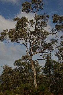
Eucalyptus wandoo, commonly known as wandoo, dooto, warrnt or wornt and sometimes as white gum, is a small to medium-sized tree that is endemic to the southwest of Western Australia. It has smooth bark, lance-shaped adult leaves, flower buds in groups of nine to seventeen, white flowers and conical to cylindrical fruit. It is one of a number of similar Eucalyptus species known as wandoo.
E. wandoo was first described in 1934 by the Australian botanist William Faris Blakely in his book A Key to the Eucalypts using material collected by the English collector Augustus Frederick Oldfield from a sand plain along the Kalgan River. , Plants of the World Online lists Eucalyptus redunca var. elata as a taxonomic synonym of E. wandoo. (Full article...) -
John Biase D'Orazio (Italian: [ˈbjaːze doˈrattsjo]; 5 September 1955 – 11 April 2011) was an Australian politician who served as the member for Ballajura in the Western Australian Legislative Assembly from 10 February 2001 to 6 September 2008. He was a minister in the governments of Geoff Gallop and Alan Carpenter, and a member of the Australian Labor Party until 29 August 2006, when he resigned following several controversies. Born to Italian immigrants, D'Orazio grew up on a market garden in the Perth suburb of Bayswater. He studied pharmacy at the Western Australian Institute of Technology, later opening his own pharmacy business. In 1981, he was elected to the Bayswater council, and in 1984, he became the mayor of Bayswater, in which position he served until 2001.
At the 2001 Western Australian state election, D'Orazio was elected to the seat of Ballajura in the Western Australian Legislative Assembly, beating the Liberal incumbent Rhonda Parker. Following the 2005 state election, he was promoted to cabinet by Premier Geoff Gallop, becoming the minister for justice and minister for small business. On 3 February 2006, after Alan Carpenter became Premier, D'Orazio was appointed as the minister for police and emergency services, minister for justice, and minister for community safety. (Full article...) -

Operation Mosaic was a series of two British nuclear tests conducted in the Montebello Islands in Western Australia on 16 May and 19 June 1956. These tests followed the Operation Totem series and preceded the Operation Buffalo series. The second test in the series was the largest ever conducted in Australia.
The purpose of the tests was to explore increasing the yield of British nuclear weapons through boosting with lithium-6 and deuterium, and the use of a natural uranium tamper. Although a boosted fission weapon is not a hydrogen bomb, which the British Government had agreed would not be tested in Australia, the tests were connected with the British hydrogen bomb programme. (Full article...) -
Tonkin Highway is an 81-kilometre-long (50 mi) north–south highway and partial freeway in Perth, Western Australia, linking Perth Airport and Kewdale with the city's north-eastern and south-eastern suburbs. As of April 2020, the northern terminus is at the interchange with Brand Highway and Great Northern Highway in Muchea, and the southern terminus is at Thomas Road in Oakford. It forms the entire length of State Route 4, and connects to several major roads. Besides Brand Highway and Great Northern Highway, it also connects to Reid Highway, Great Eastern Highway, Leach Highway, Roe Highway, and Albany Highway.
Planning for the route began in the 1950s, but the first segment between Wattle Grove and Cloverdale was not opened until 1980. Over the next five years, the highway was extended north to Great Eastern Highway and south to Albany Highway, and a discontinuous section was constructed north of the Swan River. In 1988 the Redcliffe Bridge linked these sections, and three years later, Reid Highway became the northern terminus. The next major works on the highway, between 2003 and 2005, extended the highway south to Thomas Road. (Full article...)


.png)


Did you know (auto-generated)

- ... that Western Australia was the second Australian state to legalise voluntary assisted dying?
- ... that Bill Dunn, an Indigenous Australian pastoralist approaching retirement, sold his station at half-price to the Jigalong community despite receiving full-price offers from non-Indigenous people?
- ... that Nick Goiran, a member of the Western Australian Legislative Council, proposed 357 amendments to a voluntary assisted dying bill?
- ... that Mertome Village in Bayswater, Western Australia was the first aged care complex to be built by a local government in Australia?
- ... that the search for a lost radioactive capsule along a 1,400-kilometre (870 mi) stretch of road in Western Australia was likened to looking for a needle in a haystack?
- ... that politician John D'Orazio helped to secure a three-year trial of daylight saving time in Western Australia?
Categories

More portals
More did you know...

- ...that when the 1987 America's Cup was raced off Fremantle, Western Australia it was the first time for 132 years that the regatta had not been hosted by the New York Yacht Club?
- ...that the original Victoria Dam, constructed in 1891, was the first dam in Western Australia, and it stood for almost 100 years before being replaced with the current dam?
- ...that Anglican bishop Kay Goldsworthy was consecrated as the first woman bishop of any Australian church on 22 May 2008?
Related WikiProjects

Things you can do
Here are some tasks you can do to help with WikiProject Western Australia:
Associated Wikimedia
The following Wikimedia Foundation sister projects provide more on this subject:
-
 Commons
Free media repository -
 Wikibooks
Free textbooks and manuals -
 Wikidata
Free knowledge base -
 Wikinews
Free-content news -
 Wikiquote
Collection of quotations -
 Wikisource
Free-content library -
 Wikispecies
Directory of species -
 Wikiversity
Free learning tools -
 Wikivoyage
Free travel guide -
 Wiktionary
Dictionary and thesaurus


