Portal:Oceania
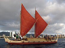
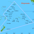
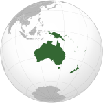
The Oceania PortalOceania (UK: /ˌoʊsiˈɑːniə, ˌoʊʃi-, -ˈeɪn-/ OH-s(h)ee-AH-nee-ə, -AY-, US: /ˌoʊʃiˈæniə, -ˈɑːn-/ ⓘ OH-shee-A(H)N-ee-ə) is a geographical region comprising Australasia, Melanesia, Micronesia, and Polynesia. Spanning the Eastern and Western Hemispheres, at the centre of the water hemisphere, Oceania is estimated to have a land area of about 9,000,000 square kilometres (3,500,000 sq mi) and a population of around 44.4 million as of 2022. When compared to the other continents, Oceania is the smallest in land area and the second-least populated after Antarctica. Oceania has a diverse mix of economies from the highly developed and globally competitive financial markets of Australia, French Polynesia, Hawaii, New Caledonia, and New Zealand, which rank high in quality of life and Human Development Index, to the much less developed economies of Kiribati, Papua New Guinea, Tuvalu, Vanuatu, and Western New Guinea, while also including medium-sized economies of Pacific islands such as Fiji, Palau, and Tonga. The largest and most populous country in Oceania is Australia, and the largest city is Sydney. Puncak Jaya in Highland Papua, Indonesia, is the highest peak in Oceania at 4,884 m (16,024 ft). The arrival of European settlers in subsequent centuries resulted in a significant alteration in the social and political landscape of Oceania. The Pacific theatre saw major action during the First World War with the Japanese occupying many German territories. During the Second World War, Allied powers the United States, Philippines (a U.S. Commonwealth at the time) and Australia fought against Axis power Japan across various locations in Oceania. (Full article...) Selected geographic article - Niue (/ˈnjuːeɪ/, /niːˈjuːeɪ/; Niuean: Niuē) is a self-governing island country in free association with New Zealand. It is situated in the South Pacific Ocean and is part of Polynesia, and predominantly inhabited by Polynesians. The island is commonly referred to as "The Rock", which comes from the traditional name "Rock of Polynesia". Niue is located in a triangle between Tonga, Samoa, and the Cook Islands. It is 2,400 kilometres (1,500 mi) northeast of New Zealand, and 604 kilometres (375 mi) northeast of Tonga. Niue's land area is about 261.46 square kilometres (100.95 sq mi) and its population was 1,689 at the Census in 2022. Niue is one of the world's largest coral islands. The terrain of the island has two noticeable levels. The higher level is made up of a limestone cliff running along the coast, with a plateau in the centre of the island reaching approximately 60 metres (200 ft) above sea level. The lower level is a coastal terrace approximately 0.5 km (0.3 miles) wide and about 25–27 metres (80–90 feet) high, which slopes down and meets the sea in small cliffs. A coral reef surrounds the island, with the only major break in the reef being in the central western coast, close to the capital, Alofi. Niue is subdivided into 14 villages (municipalities). Each village has a council that elects its chairperson. The villages are at the same time electoral districts; each village sends an assemblyperson to the Niue Assembly (parliament). (Full article...)Related portalsSelected article - Polynesian navigation or Polynesian wayfinding was used for thousands of years to enable long voyages across thousands of kilometres of the open Pacific Ocean. Polynesians made contact with nearly every island within the vast Polynesian Triangle, using outrigger canoes or double-hulled canoes. The double-hulled canoes were two large hulls, equal in length, and lashed side by side. The space between the paralleled canoes allowed for storage of food, hunting materials, and nets when embarking on long voyages. Polynesian navigators used wayfinding techniques such as the navigation by the stars, and observations of birds, ocean swells, and wind patterns, and relied on a large body of knowledge from oral tradition. This island hopping was a solution to the scarcity of useful resources, such as food, wood, water, and available land, on the small islands in the Pacific Ocean. When an island’s required resources for human survival began to run low, the island's inhabitants used their maritime navigation skills and set sail for new islands. However, as an increasing number of islands in the South Pacific became occupied, and citizenship and national borders became of international importance, this was no longer possible. People thus became trapped on islands with the inability to support them. Navigators travelled to small inhabited islands using wayfinding techniques and knowledge passed by oral tradition from master to apprentice, often in the form of song. Generally, each island maintained a guild of navigators who had very high status; in times of famine or difficulty, they could trade for aid or evacuate people to neighbouring islands. As of 2014, these traditional navigation methods are still taught in the Polynesian outlier of Taumako in the Solomons and by voyaging societies throughout the Pacific. (Full article...)Did you know -
General images -The following are images from various Oceania-related articles on Wikipedia.
TopicsSubcategoriesThings you can doAssociated WikimediaThe following Wikimedia Foundation sister projects provide more on this subject:
In other languagesWikipedia in other languages used in Oceania:
More portals |


