Portal:Peru
Introduction
Peru, officially the Republic of Peru, is a country in western South America. It is bordered in the north by Ecuador and Colombia, in the east by Brazil, in the southeast by Bolivia, in the south by Chile, and in the south and west by the Pacific Ocean. Peru is a megadiverse country with habitats ranging from the arid plains of the Pacific coastal region in the west to the peaks of the Andes mountains extending from the north to the southeast of the country to the tropical Amazon basin rainforest in the east with the Amazon River. Peru has a population of over 32 million, and its capital and largest city is Lima. At 1,285,216 km2 (496,225 sq mi), Peru is the 19th largest country in the world, and the third largest in South America. Peruvian territory was home to several cultures during the ancient and medieval periods, and has one of the longest histories of civilization of any country, tracing its heritage back to the 10th millennium BCE. Notable pre-colonial cultures and civilizations include the Caral–Supe civilization (the earliest civilization in the Americas and considered one of the cradles of civilization), the Nazca culture, the Wari and Tiwanaku empires, the Kingdom of Cusco, and the Inca Empire, the largest known state in the pre-Columbian Americas. The Spanish Empire conquered the region in the 16th century and Charles V established a viceroyalty with the official name of the Kingdom of Peru that encompassed most of its South American territories, with its capital in Lima. Higher education started in the Americas with the official establishment of the National University of San Marcos in Lima in 1551. Peru's population includes Mestizos, Amerindians, Europeans, Africans and Asians. The main spoken language is Spanish, although a significant number of Peruvians speak Quechuan languages, Aymara, or other Indigenous languages. This mixture of cultural traditions has resulted in a wide diversity of expressions in fields such as art, cuisine, literature, and music. (Full article...) Entries here consist of Good and Featured articles, which meet a core set of high editorial standards.
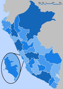 According to the Organic Law of Regional Governments, the regions (Spanish: regiones) are, with the departments, the first-level administrative subdivisions of Peru. Since its 1821 independence, Peru had been divided into departments (departamentos) but faced the problem of increasing centralization of political and economic power in its capital, Lima. After several unsuccessful regionalization attempts, the national government decided to temporarily provide the departments (including the Constitutional Province of Callao) with regional governments until the conformation of regions according to the Organic Law of Regional Governments which says that two or more departments should merge to conform a region. This situation turned the departments into de facto regional government circumscriptions. The first regional governments were elected on November 20, 2002. (Full article...)Selected image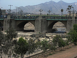 Photo credit: Ericbronder
The Rímac River runs through the Peruvian capital of Lima and is the city's main source of water. One of the oldest bridges spanning the river is the Puente de Piedra (Stone Bridge) built out in stone masonry in the early 17th century. The bridge is still in use and connects the two districts that comprise the Historic Center of Lima: Rímac and Lima Cercado. (more...) Selected battleThe Battle of Arica, also known as Assault and capture of Arica Cape, is a belic action of the War of the Pacific. It was fought on June 7, 1880, between forces of Chile and Peru. After the Battle of Tacna, and the following Bolivian retirement of the war, Peru had to stand alone for the rest of the conflict. The need of a port near to the location of the army, in order to supply and reinforce the troops and the evacuation of the wounded, made the Chilean command to put its attention on the remaining Peruvian stronghold in the Tacna Department. Thus, a fraction of the Chilean army, led by Colonel Pedro Lagos, launched a simultaneous assault from both sides, taking the defenses on a bayonet charge, and captured the Morro de Arica (English: Arica Cape) from the defending Peruvian troops under the command of Colonel Francisco Bolognesi in a last attack up the hill. In this fight the Peruvian Commander died along with several officers and more than 1.000 men. (more...) In this month
General imagesThe following are images from various Peru-related articles on Wikipedia.
Selected article -The Ecuadorian–Peruvian territorial dispute was a territorial dispute between Ecuador and Peru, which, until 1928, also included Colombia. The dispute had its origins on each country's interpretation of what Real Cedulas Spain used to precisely define its colonial territories in the Americas. After independence, all of Spain's colonial territories signed and agreed to proclaim their limits in the basis of the principle of uti possidetis juris, which regarded the Spanish borders of 1810 as the borders of the new republics. However, conflicting claims and disagreements between the newly formed countries eventually escalated to the point of armed conflicts on several occasions. The dispute de jure had come to an end in the aftermath of the Ecuadorian–Peruvian War with the signing of the Rio de Janeiro Protocol on January 29, 1942. However, this treaty was also questioned, and the two countries went to war on two more occasions: the Paquisha War in 1981, and the Cenepa War in 1995. Tensions subsided but persisted over the next three years. On October 26, 1998, Ecuador and Peru signed a comprehensive peace accord that established a framework for ending a border dispute. Formal demarcation of border regions started on May 13, 1999. The agreement was ratified without opposition by the congresses of both nations, finally bringing a definitive end to the dispute. (Full article...)Did you know (auto-generated) -
CategoriesRelated portalsSelected quote -
South American revolutionary leader, liberator and dictator of Peru Simón Bolívar 1783–1830
Basic facts & figuresMore did you know...
Peru TopicsRecognized content
Featured articlesFeatured listsGood articles
WikiProjectsThings you can do
New articlesThis list was generated from these rules. Questions and feedback are always welcome! The search is being run daily with the most recent ~14 days of results. Note: Some articles may not be relevant to this project.
Rules | Match log | Results page (for watching) | Last updated: 2024-05-13 21:47 (UTC) Note: The list display can now be customized by each user. See List display personalization for details.
Associated WikimediaThe following Wikimedia Foundation sister projects provide more on this subject:
Discover Wikipedia using portals | |||||||||||||||


