
User:Ɱ/Portal:Columbus, Ohio
Portal maintenance status: (October 2021)
|
Introduction

Columbus (/kəˈlʌmbəs/, kə-LUM-bəs) is the capital and most populous city of the U.S. state of Ohio. With a 2020 census population of 905,748, it is the 14th-most populous city in the U.S., the second-most populous city in the Midwest after Chicago, and the third-most populous U.S. state capital after Phoenix, Arizona and Austin, Texas. Columbus is the seat of government of Franklin County; it also extends into Delaware and Fairfield counties. It is the core city of the Columbus metropolitan area, which encompasses ten counties in central Ohio. It had a population of 2,138,926 in 2020, making it the largest metropolitan area entirely in Ohio and 32nd-largest metro area in the U.S.
Columbus originated as numerous Native American settlements on the banks of the Scioto River. Franklinton, now a city neighborhood, was the first European settlement, laid out in 1797. The city was founded in 1812 at the confluence of the Scioto and Olentangy rivers, and laid out to become the state capital. The city was named for Italian explorer Christopher Columbus. The city assumed the function of state capital in 1816 and county seat in 1824. Amid steady years of growth and industrialization, the city has experienced numerous floods and recessions. Beginning in the 1950s, Columbus began to experience significant growth; it became the largest city in Ohio in land and population by the early 1990s. Growth has continued in the 21st century, with redevelopment occurring in numerous city neighborhoods, including Downtown. (Full article...)
Selected general articles
-
 Holly Hill is a neighborhood located in West Columbus, Columbus, Ohio, United States. Holly Hill is a traditional 1960s suburban neighborhood consisting of mostly brick ranch houses and some bi-level houses. The houses range in size from approximately 860 square feet (80 m2) up to 1,500 square feet (140 m2). Holly Hill is located next to Georgian Heights. (Full article...)
 -
The Joseph P. Kinneary United States Courthouse is a federal courthouse in Columbus, Ohio, in the city's downtown Civic Center. It was formerly known as the U.S. Post Office and Court House. It was designed by Richards, McCarty & Bulford and was completed in 1934. The supervising architect was James A. Wetmore. It was renamed for Joseph P. Kinneary in 1998. It is still in use by the U.S. District Court for the Southern District of Ohio. (Full article...)
-
Milo-Grogan is a neighborhood of Columbus, Ohio. The neighborhood was settled as the separate communities of Milo and Grogan in the late 1870s. Large-scale industrial development fueled the neighborhood's growth until the 1980s, when the last factories closed. The community has received urban renewal efforts in recent years fueled by the Columbus Department of Development and Milo-Grogan Area Commission. (Full article...)
-
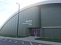
Columbus City Hall is the city hall of Columbus, Ohio, in the city's downtown Civic Center. It contains the offices of the city's mayor, auditor, and treasurer, and the offices and chambers of Columbus City Council.
City Hall was designed in a Neoclassical style by the Allied Architects Association of Columbus. It replaced offices in the Central Market building as well as a former permanent city hall. The new city hall was built from 1926 to 1928, during a period of extensive construction building the city's riverfront civic center. An additional wing was added to City Hall in 1936. Renovations took place in 1949 and 1986, and the building was determined to be eligible for the National Register of Historic Places as part of a historic district in 1988. (Full article...) -

The Columbus Museum of Art (CMA) is an art museum in downtown Columbus, Ohio. Formed in 1878 as the Columbus Gallery of Fine Arts (its name until 1978), it was the first art museum to register its charter with the state of Ohio. The museum collects and exhibits American and European modern and contemporary art, folk art, glass art, and photography. The museum has been led by Executive Director Brooke Minto since 2023. (Full article...) -

Smart Columbus is an innovation organization in Columbus, Ohio. The initiative is led by the City of Columbus and the Columbus Partnership, a nonprofit organization for development in Central Ohio. Smart Columbus was founded in 2016 to utilize $50 million in grant awards toward technology, transportation, and environmental developments. (Full article...) -
Columbus City Schools, formerly known as Columbus Public Schools, is the official school district for the city of Columbus, Ohio, and serves most of the city (portions of the city are served by suburban school districts). The district has 46,686 students enrolled, making it the largest school district in the state of Ohio as of June 2021. At its peak during the 1971 school year the district served 110,725 students.
The first school built in the area which is now part of Columbus was a log cabin school-house built in Franklinton, in 1806. It was not until 1845 that the state of Ohio Legislature entrusted the management of Columbus schools to a Board of Education. Two years later the school board elected Dr. Asa Lord as the district's first superintendent. Dr. Gene T. Harris served as the 19th superintendent of Columbus City Schools and was succeeded by Dr. Dan Good. For most of its history, the district has been referred to as "Columbus Public Schools". In August 2007, the district decided to begin using its official name of "Columbus City Schools." (Full article...) -
The culture of Columbus, Ohio, is particularly known for museums, performing arts, sporting events, seasonal fairs and festivals, and architecture of various styles from Greek Revival to modern architecture. (Full article...)
-
The Ohio Theatre is a performing arts center and former movie palace on Capitol Square in Downtown Columbus, Ohio. Known as the "Official Theatre of the State of Ohio", the 1928 building was saved from demolition in 1969 and was later completely restored. The theater was declared a National Historic Landmark in 1977.
The Ohio Theatre is owned and operated by the non-profit arts management organization CAPA (The Columbus Association for the Performing Arts), which was originally formed to save the theater in 1969. (Full article...) -
The Columbus Zoo and Aquarium is a non-profit zoo located near Powell in Liberty Township, Delaware County, Ohio, United States, north of the city of Columbus. The land lies along the eastern banks of the O'Shaughnessy Reservoir on the Scioto River, at the intersection of Riverside Drive and Powell Road. It has a worldwide reputation, largely attributable to the efforts and promotion of director emeritus Jack Hanna. In 2009, it was named by the USA Travel Guide as the number one zoo in the United States. It was also ranked number one best zoo in 2012 by Besties Readers Choice.
The Columbus Zoo is home to more than 7,000 animals representing over 800 species and sees over 2 million visitors annually. The animal exhibits are divided into regions of the world, with the zoo currently operating eight such regions. In addition the zoo owns an 18-hole golf course, known as the Safari Golf Club which encompasses 56.656 hectares (140 acres). The zoo also owns Zoombezi Bay which encompasses 9.187 hectares (22.70 acres). In total, the zoo owns 234 hectares (580 acres) of land, with 164.424 hectares (406.30 acres) dedicated to the zoo itself.[needs update]
The zoo operates its own conservation program, donating money to outside programs as well as participating in their own conservation efforts. Over the past five years the zoo has contributed over $3.3 million to more than 70 projects in 30 countries. The zoo also has a close working relationship with the Wilds, a 9,154-acre (37.04 km2) animal conservation center located in southeast Ohio and featured on the Columbus Zoo's website. (Full article...) -

Bolton Field (ICAO: KTZR, FAA LID: TZR) is a public airport in Columbus, Franklin County, Ohio, United States. It is a towered airport operated under the Columbus Regional Airport Authority. It is one of 12 general aviation reliever airports in Ohio recognized in the National Plan of Integrated Airport Systems (NPIAS) and is a reliever airport for John Glenn Columbus International Airport.
Most U.S. airports use the same three-letter location identifier for the FAA and IATA, but Bolton Field is TZR to the FAA and has no IATA code. (Full article...) -

The Billy Ireland Cartoon Library & Museum is a research library of American cartoons and comic art affiliated with the Ohio State University library system in Columbus, Ohio. Formerly known as the Cartoon Research Library and the Cartoon Library & Museum, it holds the world's largest and most comprehensive academic research facility documenting and displaying original and printed comic strips, editorial cartoons, and cartoon art. The museum is named after the Ohio cartoonist Billy Ireland.
Covering comic books, daily strips, Sunday strips, editorial cartoons, graphic novels, magazine cartoons, and sports cartoons, the collection includes 450,000 original cartoons, 36,000 books, 51,000 serial titles, and 3,000 feet (910 m) of manuscript materials, plus 2.5 million comic strip clippings and tear sheets. (Full article...) -
Harrison West is a historic urban neighborhood located northwest of downtown Columbus, Ohio. It sits on several blocks along the Olentangy River and includes the western part of the Near Northside Historic District, which was placed on the National Register of Historic Places in 1975. The character of the neighborhood is similar to Victorian Village, which sits just to the east and is more well-known. (Full article...) -
Thurber House is a literary center for readers and writers located in Columbus, Ohio, in the historic former home of author, humorist, and New Yorker cartoonist James Thurber. Thurber House is dedicated to promoting the literary arts by presenting quality literary programming; increasing the awareness of literature as a significant art form; promoting excellence in writing; providing support for literary artists; and commemorating Thurber's literary and artistic achievements. The house is individually listed on the National Register of Historic Places, and also as part of the Jefferson Avenue Historic District. (Full article...) -
Schumacher Place is a neighborhood in Columbus, Ohio. It is bordered on the north by East Livingston Avenue, the east by Parsons Avenue, the south by East Whittier Street, and the west by Lathrop Street, Brust Street, South Grant Avenue, and Jaeger Street.
The neighborhood borders German Village, an upscale neighborhood to the west. Schumacher Place is similar, with century-old brick houses and brick streets. The neighborhood is however more affordable and has fewer construction and renovation restrictions. The neighborhood is also known for its car museum, the Wagner-Hagans Auto Museum. The museum, a small privately owned organization, offers free admission by appointment. It holds the collections of Steve Wagner (primarily unusual cars) and Mark Hagans (primarily cars of the 1930s).
Schumacher Place is named for a family that operated a dairy company there in the 1800s, in the southeast corner of the neighborhood. (Full article...) -
-
Riverbend is a neighborhood in southwest Columbus, Ohio. Riverbend itself is a single subdivision that is located next to Big Run Park. Because Riverbend is at the southwest border of the city, it was not annexed into the city until the late 1960s. A major road that serves as the northern boundary of the neighborhood, Clime Road, has segments that have yet to be annexed into the city. (Full article...)
-
Clintonville is a suburban neighborhood in north-central Columbus, Ohio, United States with around 30,000 residents. Its borders, associated with the Clintonville Area Commission, are the Olentangy River on the west, Glen Echo Creek to the south, a set of railroad tracks to the east, and on the north by the Worthington city limits.
As the cachet of the Clintonville neighborhood grew towards the turn of the 21st century, real estate agents began to label homes north of Cooke Road as Clintonville or Clintonville or Beechwold thus leading to the apparent absorption of Beechwold and nearby Columbus subdivisions south of Worthington. The area also contains the former unincorporated community of Evanston, a name that was used by the Big Four Railroad as a station along its line and U.S. Postal service until the 1920s. Clintonville includes parts of ZIP codes 43202 and 43214. The United States Post Offices at the center of each ZIP code are known as Clintonville Station and Beechwold Station, respectively. (Full article...) -
Clinton Township is one of the seventeen townships of Franklin County, Ohio, United States. The 2020 census found 4,499 people in the township. (Full article...) -
77 North Front Street is a municipal office building of Columbus, Ohio, in the city's downtown Civic Center. The building, originally built as the Central Police Station (of the current-day Columbus Division of Police) in 1930, operated in that function until 1991. After about two decades of vacancy, the structure was renovated for city agency use in 2011.
The building was included in the Columbus Civic Center Historic District, nominated to the National Register of Historic Places in 1988. (Full article...) -

The James A. Rhodes State Office Tower is a 41-story, 629-foot (192 m) state office building and skyscraper on Capitol Square in Downtown Columbus, Ohio. The Rhodes Tower is the tallest building in Columbus and the fifth tallest in Ohio. The tower is named for James A. Rhodes, the longest-serving Ohio governor, and features a statue of Rhodes outside the entrance. The building's interior includes a large open lobby with 22 elevators. Higher floors have offices for numerous state agencies. The tower's 40th floor contains an observation deck, open to the public.
The Rhodes Tower was designed by Brubaker/Brandt and Dalton, Dalton, Little, and Newport in a Modernist style. It was conceived in 1969 as a way to consolidate state offices in one building and give more space to legislative offices in the Ohio Statehouse. Construction spanned from 1971 to 1974; it has held state offices since mid-1974, including the Supreme Court of Ohio until it moved to the renovated Ohio Judicial Center in 2004. The Rhodes Tower was renovated from 2018 to 2022 for energy savings and façade maintenance. (Full article...) -
The Arena District is a mixed-use planned development and neighborhood in Columbus, Ohio. The site was developed through a partnership between Nationwide Realty Investors, Ltd. (a subsidiary of Nationwide), the City of Columbus and private investors. Interpretation of the boundaries of the district are evolving as the neighboring blocks around the original 75-acre (300,000 m2) site have seen additional commercial and residential development. The Arena District is named for Nationwide Arena. (Full article...) -
The Columbus Division of Fire (CFD) provides fire protection and emergency medical services to Columbus, Ohio.
The department operates 35 stations; the newest station opened March 2020. The stations are divided into seven battalions. The Columbus Division of Fire oversees 35 engine companies, 16 ladder companies, 5 rescue companies, and 40 EMS transport vehicles as well as several special units and reserve apparatus. It is staffed by a minimum of 292 personnel during daytime hours (first 12 hours) and 331 during nighttime hours (second 12 hours). The department also oversees 39 medic companies. There are 1,592 uniformed and 70 civilian professionals serving the citizens of Columbus, Ohio.
The department is accredited by the Committee on Fire Accreditation International, granted in 2007. At the time, it was the second-largest fire department with the accreditation. (Full article...) -
Olde Towne East is a neighborhood located in the historical Near East Side of Columbus, Ohio and is one of Columbus' oldest neighborhoods. The area has over 1,000 homes, some as old as the 1830s, and more than 50 architectural styles as a result of its history. These homes were built by many of the famous individuals of Columbus including industrialists, lawyers, judges, teachers, architects, mayors, governors, and legislators, many of whom shaped the city. (Full article...) -
Columbus Japanese Language School (コロンバス日本語補習校, Koronbasu Nihongo Hoshūkō, CJLS) is a weekend supplementary Japanese school, based in the Columbus, Ohio metropolitan area.
The classes are held in Creekview Intermediate School, of the Marysville Exempted Village Schools District (MEVSD) in Marysville. The school office is located in Worthington. (Full article...)


Need help?
Do you have a question about Columbus, Ohio that you can't find the answer to?
Consider asking it at the Wikipedia reference desk.
Selected images
-
 COSI (east entrance pictured) features themed, interactive science exhibits. (from Columbus, Ohio)
 -

-
 Ohio Stadium, on the campus of Ohio State University, is the 5th-largest non-racing stadium in the world. (from Columbus, Ohio)
 -

-
-
-

-
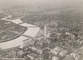
 View of the city from Capital University in 1854 (from History of Columbus, Ohio)
 -

-
 The Scioto Mile includes nine parks along both banks of the Scioto River between downtown Columbus and Franklinton. (from Columbus, Ohio)
 -
-
 Audubon nature center at Scioto Audubon Metro Park, the first built close to a major city's downtown (from Columbus, Ohio)
 -
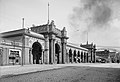
 Arcade of the third Union Station, the city's rail station from 1897 to 1977 (from Columbus, Ohio)
 -
 Shrum Mound in Campbell Memorial Park (from Columbus, Ohio)
 -

-
 The Ohio State Fair is held in late July to early August. (from Columbus, Ohio)
 -
Central Market stood on Fourth Street from 1850 to 1966 (from History of Columbus, Ohio)
-
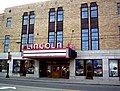 The historic Lincoln Theatre (from Neighborhoods in Columbus, Ohio)
 -
-
 The Columbus Museum of Art collects and exhibits American and European modern and contemporary art, folk art, glass art, and photography. (from Columbus, Ohio)
 -
View of the city from Capital University in 1854 (from Columbus, Ohio)
-

-
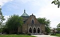
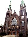
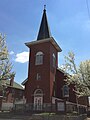 Hungarian Reform Church, in Hungarian Village (from Neighborhoods in Columbus, Ohio)
 -
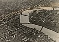 Downtown Columbus and the Scioto River c. 1924 (from Columbus, Ohio)
 -
-
 Camp Chase as it stands today, a memorial to fallen soldiers from the American Civil War. (from Neighborhoods in Columbus, Ohio)
 -
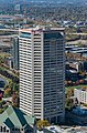
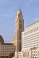
 The Art Deco LeVeque Tower is the city's second-tallest skyscraper. (from Columbus, Ohio)
 -
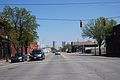 West Broad Street in Franklinton (from Neighborhoods in Columbus, Ohio)
 -
 Italian Village rowhouse (from Neighborhoods in Columbus, Ohio)
 -

-
 Dutch Colonial Style residences in Hungarian Village (from Neighborhoods in Columbus, Ohio)
 -
 Victorian houses facing Goodale Park in Victorian Village (from Columbus, Ohio)
 -
 Victorian-style homes located along Goodale Park (from Neighborhoods in Columbus, Ohio)
 -
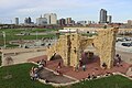
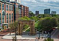 Located in the Arena District, McFerson Commons is home to the Union Station arch. (from Columbus, Ohio)
 -
 Lou Berliner Sports Park (from List of parks in Columbus, Ohio)
 -
 Four of the city's five tallest buildings are around Capitol Square (from List of tallest buildings in Columbus, Ohio)
 -
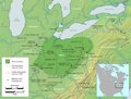 Map of the Ohio Country between 1775 and 1794, depicting locations of battles and massacres surrounding the area that would eventually become Ohio (from History of Columbus, Ohio)
 -
 Bird's eye view map of Columbus in 1872 (from Columbus, Ohio)
 -
 The Merion Village arch (from Neighborhoods in Columbus, Ohio)
 -
 Hilltop signage (from Neighborhoods in Columbus, Ohio)
 -
 St. Mary Magdalene Church in Westgate (from Neighborhoods in Columbus, Ohio)
 -
 Home in Old Oaks (from Neighborhoods in Columbus, Ohio)
 -
The city c. 1924 (from History of Columbus, Ohio)
-
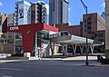 COTA's Spring Street Terminal, one of its five transit centers (from Columbus, Ohio)
 -
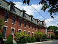
 Eastern side of Olentangy Commons (from Neighborhoods in Columbus, Ohio)
 -
 Historic Home in Harrison West (from Neighborhoods in Columbus, Ohio)
 -

-
 Map of land surveys and city boundary growth, 1812–1920 (from History of Columbus, Ohio)
 -
 Holy Rosary and Saint John Church (from Neighborhoods in Columbus, Ohio)
 -
 Skyline of Columbus (Use cursor to identify buildings) (from List of tallest buildings in Columbus, Ohio)
 -

-
 Big Run Sports Complex, in Big Run Park (from Neighborhoods in Columbus, Ohio)
 -
 Port Columbus Airport tower and terminal from 1929 to 1958 (from Columbus, Ohio)
 -
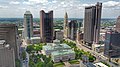
 Municipal offices, including the Columbus Division of Police Headquarters, in the city's Civic Center (from Columbus, Ohio)
 -
-
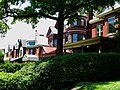
 Homes in German Village (from Neighborhoods in Columbus, Ohio)
 -

-
-
 Indianola Junior High School was the first middle school in the U.S. (from Columbus, Ohio)
 -
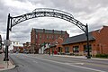
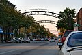 The iconic arches of the Short North (from Neighborhoods in Columbus, Ohio)
 -
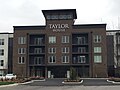 Taylor House on Bethel Rd. (from Neighborhoods in Columbus, Ohio)
 -
-
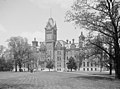
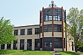
 The Pontifical College Josephinum (1888-1931) (from List of demolished buildings and structures in Columbus, Ohio)
 -
 Columbus in 1936 (from History of Columbus, Ohio)
 -
Shrum Mound, the feature of Campbell Memorial Park (from History of Columbus, Ohio)
-
-
 Street arches returned to the Short North in late 2002. (from History of Columbus, Ohio)
 -
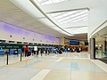 John Glenn Columbus International Airport departure level (from Columbus, Ohio)
 -
 Racial distribution in Columbus in 2010: ⬤ White ⬤ Black ⬤ Asian ⬤ Hispanic ⬤ Other (from Columbus, Ohio)
 -
 Old North Columbus Arch (from Neighborhoods in Columbus, Ohio)
 -
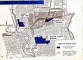 1954 urban renewal map of Columbus (from List of demolished buildings and structures in Columbus, Ohio)
 -
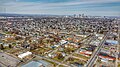
 Aerial satellite image of Columbus (from Columbus, Ohio)
 -
-
 The Santa Maria Ship & Museum, a Santa María replica, was docked downtown from 1991 to 2014. (from Columbus, Ohio)
 -
Bird's eye view map of Columbus in 1872 (from History of Columbus, Ohio)
-
 The LeVeque Tower was the tallest building in Columbus from 1927 to 1973. (from List of tallest buildings in Columbus, Ohio)
 -

-
Map of the Ohio Country between 1775 and 1794, depicting locations of battles and massacres surrounding the area that would eventually become the U.S. state of Ohio (from Columbus, Ohio)
-
 Panorama of downtown Columbus from the Main Street Bridge (from Columbus, Ohio)
 -
The city in 1936 (from Columbus, Ohio)
-
 Locations of numbered streets and avenues (from Columbus, Ohio)
 -
-
 Barlouie (from Neighborhoods in Columbus, Ohio)
 -
 Brewery District Scene (from Neighborhoods in Columbus, Ohio)
 -
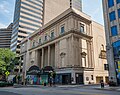
 Columbus City Hall (from Columbus, Ohio)
 -
 North Market (from Columbus, Ohio)
 -
Central Market, pictured here in 1898, operated from 1814 to 1966. (from Columbus, Ohio)
-

-
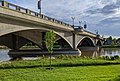 The Discovery Bridge (from Columbus, Ohio)
 -
2010 Census-based map: red dots indicate white Americans, blue dots for African Americans, green for Asian Americans, orange for Hispanic Americans, yellow for other races. Each dot represents 25 residents. (from Neighborhoods in Columbus, Ohio)
-
 Aerial view of Reeb-Hosack (from Neighborhoods in Columbus, Ohio)


.jpg)


.jpg)
_crop.jpg)


_-_exterior_2.jpg)


.jpg)

.jpg)


.jpg)


.png)


Subcategories

- Select [►] to view subcategories
Subtopics
| Topics |  | ||||||
|---|---|---|---|---|---|---|---|
| Neighborhoods | |||||||
| Enclaves | |||||||
| History |
| ||||||
| Attractions | |||||||
| Government |
| ||||||
| Education |
| ||||||
| Transportation |
| ||||||
| Sports |
| ||||||
| Museums |
| ||||||
| |||||||
Associated Wikimedia
The following Wikimedia Foundation sister projects provide more on this subject:
-
 Commons
Free media repository -
 Wikibooks
Free textbooks and manuals -
 Wikidata
Free knowledge base -
 Wikinews
Free-content news -
 Wikiquote
Collection of quotations -
 Wikisource
Free-content library -
 Wikiversity
Free learning tools -
 Wiktionary
Dictionary and thesaurus
Category:United States portals by city Category:Portals needing placement of incoming links