Portal:San Francisco Bay Area
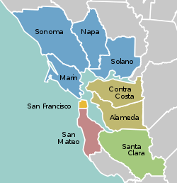
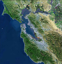
The San Francisco Bay Area Portal  The San Francisco Bay Area (referred to locally as the Bay Area) is a populous region surrounding the San Francisco and San Pablo estuaries in Northern California. The region encompasses the major cities and metropolitan areas of San Jose, San Francisco, and Oakland, along with smaller urban and rural areas. The Bay Area's nine counties are Alameda, Contra Costa, Marin, Napa, San Francisco, San Mateo, Santa Clara, Solano, and Sonoma. Home to approximately 7.68 million people, the nine-county Bay Area contains many cities, towns, airports, and associated regional, state, and national parks, connected by a network of roads, highways, railroads, bridges, tunnels, and commuter rail. The combined statistical area of the region is the second-largest in California (after the Greater Los Angeles area), the fifth-largest in the United States, and the 43rd-largest urban area in the world with 8.80 million people. The Bay Area has the second-most Fortune 500 companies in the United States, after the New York metropolitan area, and is known for its natural beauty, liberal politics, entrepreneurship, and diversity. The area ranks second in highest density of college graduates, after the Washington, D.C. metropolitan area and performs above the state median household income in the 2010 census; it includes the five highest California counties by per capita income and two of the top 25 wealthiest counties in the United States. Based on a 2013 population report from the California Department of Finance, the Bay Area is the only region in California where the rate of people migrating in from other areas in the United States is greater than the rate of those leaving the region, led by Alameda and Contra Costa counties. (more...) Selected article The San Francisco neighborhood that includes Treasure Island extends far into San Francisco Bay and includes a tip of Alameda Island. Yerba Buena and Treasure islands together have a land area of 576.7 acres (233.4 ha) with a 2010 total population of 2,500. Treasure Island and its 900 ft (270 m) causeway total 535 acres (217 ha) connected by roadway (e.g., San Francisco Muni's "108 Treasure Island") to Yerba Buena Island which has the Transbay Terminal ramps to the middle of Interstate 80's San Francisco–Oakland Bay Bridge. The island has a marina and will have a bikeway connecting to the Eastern span replacement of the San Francisco–Oakland Bay Bridge when it is completed. (more...) Selected biography Belli was born in the California Gold Rush town of Sonora, California in the Sierra foothills. His parents were of Italian ancestry from Switzerland. His grandmother Anna Mouron was the first female pharmacist in California. By the 1920s, the family had moved to the city of Stockton, California where Belli attended Stockton High School. After winning a court case, Belli would raise a Jolly Roger flag over his Montgomery Street office building in the Barbary Coast district of San Francisco (which Belli claimed had been a Gold Rush-era brothel) and fire a cannon, mounted on his office roof, to announce the victory and the impending party. (more...) Selected city In 1824 the Alhambra Valley was included in the Rancho El Pinole Mexican land grant to Ygnacio Martínez. In 1847, Dr. Robert Semple contracted to provide ferry service from Martinez to Benicia, which for many years was the only crossing on the Carquinez Strait. By 1849, Martínez served as a way station for the California Gold Rush. The town was laid out in 1849 by Col. William M. Smith and named for Martinez. It became the county seat in 1850, but could not incorporate at the time because it lacked the 200 registered voters required, and only became a city in 1876. Martinez was the home of John Muir from 1880 until his death in 1914. He was buried about a mile south of the building that is now the John Muir National Historic Site. Also nearby is the Vicente Martinez Adobe, built in 1849 by the son of Ygnacio Martinez. (more...) Selected image
The Bay Area by year1938
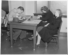
  • The 49-Mile Scenic Drive (road sign pictured, left) is created in San Francisco for the Golden Gate International Exposition by the San Francisco Down Town Association Selected historical image Original file information from NARA: "Oakland, California. High School Youth. Two Negro youngsters look over the shoulders of a couple of fortunate enough to own a model plane. The white boys can hope to become aviators." Photograph by Rondal Partridge (1940) image credit: National Archives and Records Administration
Did you know...
Previous Did you know... 
Selected periodic event Bay to Breakers is an annual footrace in San Francisco on the third Sunday of May. The name reflects the fact that the race starts at the The Embarcadero adjacent to San Francisco Bay and finishes at the Great Highway adjacent to Ocean Beach and its "breaking waves". It is well known for many participants wearing costumes, and a few engaging in public nudity. The event was officially the world's largest footrace from 1986 (with 110,000 participants) until it was surpassed in 2010 by City2Surf in Sydney, Australia. Quote
Selected multimedia file
The San Francisco Giants win game one of the 2010 World Series credit: Voice of America
Bay Area regions, geographic features and protected areasRelated PortalsWikiProject
Things you can do *Write an article on a Bay Area-related subject Selected panoramaSan Francisco Bay Area categoriesBay Area | San Francisco Bay | San Francisco | San Jose | Oakland | Cities | Census-designated places | Historic Places | National Landmarks | Counties: Alameda | Contra Costa | Marin | Napa | San Mateo | Santa Clara | Solano | Sonoma
Architecture | Attractions | Books | Culture | Economy | Education | Environment | Events & Festivals | Geography | Government | History | Landmarks | Law | Mass media | Military | Music | Organizations | Parks | People | Politics | Science | Sports | Transport
Full category tree
Select [►] to view the full category tree.
Associated WikimediaThe following Wikimedia Foundation sister projects provide more on this subject:
Discover Wikipedia using portals |
- All portals
- San Francisco Bay Area portal
- San Francisco Bay Area portal selected article pages
- San Francisco Bay Area portal selected biography pages
- San Francisco Bay Area portal selected city pages
- San Francisco Bay Area portal selected picture pages
- San Francisco Bay Area portal years pages
- San Francisco Bay Area portal selected historical image pages
- San Francisco Bay Area portal did you know pages
- San Francisco Bay Area portal festivals pages
- San Francisco Bay Area portal quotes pages
- San Francisco Bay Area portal selected multimedia pages
- San Francisco Bay Area portal selected panorama pages
- California portals
- San Francisco Bay Area
- United States portals by city


