
Portal:Andes
The Andes Portal

The Andes (/ˈændiːz/ AN-deez), Andes Mountains or Andean Mountain Range (Spanish: Cordillera de los Andes; Quechua: Anti) are the longest continental mountain range in the world, forming a continuous highland along the western edge of South America. The range is 8,900 km (5,530 mi) long and 200 to 700 km (124 to 435 mi) wide (widest between 18°S and 20°S latitude) and has an average height of about 4,000 m (13,123 ft). The Andes extend from north to south through seven South American countries: Venezuela, Colombia, Ecuador, Peru, Bolivia, Chile and Argentina.
Along their length, the Andes are split into several ranges, separated by intermediate depressions. The Andes are the location of several high plateaus—some of which host major cities such as Quito, Bogotá, Cali, Arequipa, Medellín, Bucaramanga, Sucre, Mérida, El Alto and La Paz. The Altiplano Plateau is the world's second-highest after the Tibetan Plateau. These ranges are in turn grouped into three major divisions based on climate: the Tropical Andes, the Dry Andes, and the Wet Andes.
The Andes Mountains are the highest mountain range outside Asia. The highest mountain outside Asia, Argentina's Aconcagua, rises to an elevation of about 6,961 m (22,838 ft) above sea level. The peak of Chimborazo in the Ecuadorian Andes is farther from the Earth's center than any other location on the Earth's surface, due to the equatorial bulge resulting from the Earth's rotation. The world's highest volcanoes are in the Andes, including Ojos del Salado on the Chile-Argentina border, which rises to 6,893 m (22,615 ft). (Full article...)
Selected articles
-

Laram Q'awa (Aymara larama blue, q'awa little river, ditch, crevice, fissure, gap in the earth, "blue brook" or "blue ravine", Hispanicized spellings Laram Khaua, Larancagua) is a 5,182-metre-high (17,001 ft) mountain in the Andes. According to the Bolivian IGM map 1:50,000 'Nevados Payachata Hoja 5739-I' it is situated on Bolivian terrain in the La Paz Department, Pacajes Province (Charaña Municipality), at the border with Chile. It lies north-west of the mountains Kunturiri, Phaq'u Q'awa and another mountain on the border named Laram Q'awa (Laram Khaua). One of three different rivers of this area called Kunturiri (Condoriri) originates north-east of the mountain near Phaq'u Q'awa. It flows in a bow along the northern slopes of Laram Q'awa towards Chile. (Full article...) -
Chinchillas are either of two species (Chinchilla chinchilla and Chinchilla lanigera) of crepuscular rodents of the parvorder Caviomorpha, and are native to the Andes mountains in South America. They live in colonies called "herds" at high elevations up to 4,270 m (14,000 ft). Historically, chinchillas lived in an area that included parts of Bolivia, Peru and Chile, but today, colonies in the wild are known only in Chile. Along with their relatives, viscachas, they make up the family Chinchillidae. They are also related to the chinchilla rat.
The chinchilla has the densest fur of all mammals that live on land, with around 20,000 hairs per square centimeter and 50 hairs growing from each follicle. In the water, the sea otter has a denser coat. The chinchilla is named after the Chincha people of the Andes, who once wore its dense, velvet-like fur. By the end of the 19th century, chinchillas had become quite rare after being hunted for their ultra-soft fur. Most chinchillas currently used by the fur industry for clothing and other accessories are farm-raised. Domestic chinchillas descended from C. lanigera are sometimes kept as pets, and may be considered a type of pocket pet. (Full article...) -
The Wet Andes (Spanish: Andes húmedos) is a climatic and glaciological subregion of the Andes. Together with the Dry Andes it is one of the two subregions of the Argentine and Chilean Andes. The Wet Andes runs from a latitude of 35°S to Cape Horn at 56°S. According to Luis Lliboutry the Wet Andes can be classified after the absence of penitentes. In Argentina well developed penitentes are found as south as on Lanín Volcano (40°S). Another difference is that the Wet Andes is largely devoid of rock glaciers. The glaciers of the Wet Andes have a far more stable line of equilibrium than those of the Dry Andes due to summer precipitations, low thermal oscillations and an overall high moisture. (Full article...) -
The Nevado del Quindío is an inactive volcano located in the Central Cordillera of the Andes in central Colombia. The summit marks the tripoint of the departments of Risaralda, Quindío and Tolima, and is also the highest point of the departments of Risaralda and Quindío. The mountain is one of the highest peaks in the Los Nevados National Natural Park, which is a wildlife sanctuary. There are no historical records of any eruption. The andesitic volcano is located on top of the Palestina Fault.
The snow fields and glaciers in the mountain are decreasing in a progressive way, about ten percent annually since the first scientific measures in the late 1980s, presumably because of global warming. (Full article...) -
Quilotoa (Spanish pronunciation: [kiloˈto.a]) is a water-filled crater lake and the most western volcano in the Ecuadorian Andes. The 3-kilometre (2 mi)-wide caldera was formed by the collapse of this dacite volcano following a catastrophic VEI-6 eruption about 800 years ago, which produced pyroclastic flows and lahars that reached the Pacific Ocean, and spread an airborne deposit of volcanic ash throughout the northern Andes. This last eruption followed a dormancy period of 14,000 years and is known as the 1280 Plinian eruption. The fourth (of seven) eruptive phase was phreatomagmatic, indicating that a Crater lake was already present at that time. The caldera has since accumulated a 250-metre-deep (820 ft) crater lake, which has a greenish color as a result of dissolved minerals. Fumaroles are found on the lake floor and hot springs occur on the eastern flank of the volcano.
Quilotoa is a site of growing popularity. The route to the "summit" (the small town of Quilotoa) is generally traveled by hired truck or bus from the town of Zumbahua 17 kilometres (11 mi) to the South, or more commonly by bus from Latacunga. Visitors have to pay two US dollars each to enter Quilotoa. There are a number of simple hostels in the immediate area offering services such as mules and guides. Activities include a four to five-hour hike around the caldera (whose diameter is just over 3 kilometres (2 mi)). The caldera rim is highly irregular and reaches its maximum elevations 3,810 metres (12,500 ft) to the N, 3,894 metres (12,776 ft) to the NW and 3,915 metres (12,844 ft) to the SE, at three lava domes. The 10-kilometre (6 mi) hike is sandy and steep in places and can be quite taxing, particularly if there is fog. (Full article...) -
Chimborazo (Spanish pronunciation: [tʃimboˈɾaso] ⓘ) is an inactive stratovolcano situated in the Cordillera Occidental range of the Andes. Its last known eruption is believed to have occurred around 550 A.D. Although not the tallest mountain in the Andes or on Earth relative to sea level, its summit is the farthest point on Earth's surface from the Earth's center, due to its location along the planet's equatorial bulge. Chimborazo's height is 6,263 m (20,548 ft), well below that of Mount Everest (8,849 m).
Chimborazo is the highest mountain in Ecuador and the 39th highest peak in the entire Andes. It is a popular destination for mountaineering due to its challenging climbing routes, which involve traversing snow, ice, and rocky terrain. (Full article...) -
Janq'u Uma (Aymara janq'u white, uma water, "white water", also spelled Ccancouma, Janjouma) is a mountain in the north of the Apolobamba mountain range in the Andes of Peru, about 4,900 metres (16,076 ft) high. It is located in the Puno Region, Sandia Province, Cuyocuyo District. Janq'u Uma lies northwest of the mountain Wilaquta, northeast of Qurwari and southwest of Utkhuqaqa. Two little streams named Janq'u Uma (Janjouma) and Qullqipirwa (Jolljepirhua) originate west and east of the mountain. They flow to the river Lawa Lawani which runs to the north. It belongs to the watershed of the Inambari River. (Full article...)
-
Cerro Negro de Mayasquer is a volcano on the border of Colombia and Ecuador. It lies 3 kilometres (2 mi) north-west of the volcano Chiles, and the two peaks are considered part of the same Chiles-Cerro Negro volcanic complex. These volcanoes, together with Cumbal are andesitic in rock type. A 1936 eruption reported by the Colombian government agency INGEOMINAS may have been from the Ecuadorean volcano Reventador, otherwise the volcano has not erupted for around 160,000 years. (Full article...)
-
Touching the Void is a 1988 book by Joe Simpson, recounting his and Simon Yates's near fatal descent after climbing the 6,344-metre (20,814 ft) peak Siula Grande in the Peruvian Andes. Approximately 15% of the book is written by Yates. It has sold over a million copies and has been translated into over 20 languages. (Full article...)
-

The llama (/ˈlɑːmə/; Spanish pronunciation: [ˈʎama] or [ˈʝama]) (Lama glama) is a domesticated South American camelid, widely used as a meat and pack animal by Andean cultures since the pre-Columbian era.
Llamas are social animals and live with others as a herd. Their wool is soft and contains only a small amount of lanolin. Llamas can learn simple tasks after a few repetitions. When using a pack, they can carry about 25 to 30% of their body weight for 8 to 13 km (5–8 miles). The name llama (in the past also spelled "lama" or "glama") was adopted by European settlers from native Peruvians. (Full article...) -
Chumpe (possibly from chumpi Jaqaru for corn with yellow seeds and Quechua for belt; or ch'umpi Jaqaru for red and Quechua for brown), is a mountain in the north of the Pariacaca mountain range in the Andes of Peru, about 5,200 metres (17,060 ft) high. It is situated in the Junín Region, Yauli Province, in the districts of Huay-Huay and Yauli District. Chumpe lies east of Lake Pumacocha. The mining town of San Cristóbal is situated at its feet. (Full article...) -
Lake Titicaca (/tɪtɪˈkɑːkə/; Spanish: Lago Titicaca [ˈlaɣo titiˈkaka]; Quechua: Titiqaqa Qucha) is a large freshwater lake in the Andes mountains on the border of Bolivia and Peru. It is often called the highest navigable lake in the world. Titicaca is the largest lake in South America both in terms of the volume of water and surface area.
Lake Titicaca has a surface elevation of 3,812 m (12,507 ft). The "highest lake" claim is generally considered to refer to commercial craft. Numerous smaller lakes around the world are at higher elevations. For many years, the largest vessel afloat on the lake was the 2,200-ton (2,425 U.S. tons), 79 m (259 ft) SS Ollanta. Today, the largest vessel is most likely the similarly sized train barge/float Manco Capac, operated by PeruRail. (Full article...) -
Sarapo is a mountain in the Huayhuash mountain range in the Andes of Peru, about 6,127 metres (20,102 ft) high. It is located in the Huánuco Region, Lauricocha Province, Jesús District as well as in the Lima Region, Cajatambo Province, in the districts Cajatambo and Copa. Sarapo lies south of the Yerupaja and the Siula Grande and east of the lake Sarapococha. (Full article...) -
Michincha is a stratovolcano on the border of Bolivia and Chile. It is part of an east–west trending ridge of stratovolcanoes. To its east lies Olca. The only historical activity from the complex was a flank eruption from 1865 to 1867. (Full article...)
-
Cerro Mercedario is the highest peak of the Cordillera de la Ramada range and the eighth-highest mountain of the Andes. It is located 100 km to the north of Aconcagua, in the Argentine province of San Juan. (Full article...) -
Falso Azufre is a complex volcano at the border of Argentina and Chile.
Falso Azufre is elongated in east–west direction and contains craters and lava domes; most craters have diameters of 300–600 metres (980–1,970 ft) with the exception of the main crater, which is 1 by 1.3 kilometres (0.62 mi × 0.81 mi) wide. The highest summit Cerro Falso Azufre lies at the western end in Chile, which has mostly generated pyroclastic material from craters. The probably youngest segment of the volcano is the eastern section in Argentina, where two lava domes and two cones are located; these form the Dos Conos volcano. Some lava flows linked to Dos Conos are up to 7 kilometres (4.3 mi) long. The oldest is known as the Kunstmann edifice on the northwestern side of Falso Azufre; Kunstmann volcano features a 3 kilometres (1.9 mi) wide scar formed by a sector collapse. Falso Azufre with a base surface of 387 square kilometres (149 sq mi) is one of the biggest volcanoes in the area. The presence of two oppositely curved vent alignments gives the complex an arc-like shape which reaches heights of about 5,900 metres (19,400 ft) above sea level. (Full article...) -
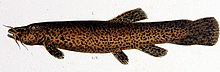
Trichomycterus rivulatus is a species of pencil catfish that is native to high-altitude Andean streams and lakes (including Junin, Poopó and Titicaca) in southern Peru, western Bolivia and northern Chile. It is the largest species in the genus Trichomycterus and grows to a maximum length of 37.4 centimetres (14.7 in) TL. The species is regularly caught as a food fish. However, because of pollution, studies have revealed levels of metals in T. rivulatus of Lake Titicaca that exceed the internationally recommended safety thresholds for human consumption. (Full article...) -
Cerro del Nacimiento is an Andean volcano of the Cordillera de la Ramada range, in the Catamarca Province of Argentina. Its summit is 6,436 metres (21,115 ft) above sea level. (Full article...) -
Mount Darwin (Spanish: Monte Darwin) is a peak in Isla Grande de Tierra del Fuego forming part of the Cordillera Darwin, the southernmost range of the Andes, just to the north of the Beagle Channel. It is 2,438 m (7,999 ft) high.
Monte Darwin was for a long time considered as the highest peak in Tierra del Fuego, but that distinction corresponds to a nearby mountain unofficially named Monte Shipton (also somewhat confusingly referred to as Darwin or Agostini-Darwin), which is about 2,580 m (8,460 ft) high and is located at . Both peaks are best climbed in late December, January, February and March. Monte Shipton was first climbed in 1962 by Eric Shipton, E. Garcia, F. Vivanco and C. Marangunic. (Full article...) -
Antisana is a stratovolcano of the northern Andes, in Ecuador. It is the fourth highest volcano in Ecuador, at 5,753 metres (18,875 ft), and is located 50 kilometres (31 mi) SE of the capital city of Quito.
Antisana presents one of the most challenging technical climbs in the Ecuadorian Andes. Next to the Pichincha, Cotopaxi, Tungurahua and Chimborazo, the Antisana belongs to the five volcanic mountains that the Prussian-born explorer Alexander von Humboldt tried to climb in 1802 during his American journey. (Full article...) -
Incahuasi (Spanish pronunciation: [iŋkaˈwasi]; possibly from Quechua: inka Inca, wasi house) is a volcanic mountain in the Andes of South America. It lies on the border of the Catamarca Province of Argentina and the Atacama Region of Chile. Incahuasi has a summit elevation of 6,621 metres (21,722 ft) above sea level.
The volcano consists of a 3.5-kilometre-wide (2.2 mi) caldera and two stratovolcanoes. Four pyroclastic cones located 7 kilometres (4.3 mi) to the northeast have produced basalt-andesite lava flows that cover an area of 10 square kilometres (4 sq mi). (Full article...) -

The Andean flicker (Colaptes rupicola) is a species of bird in subfamily Picinae of the woodpecker family Picidae. It is found in Argentina, Bolivia, Chile, Ecuador, and Peru. (Full article...) -

Lake Junin (IPA: [xuˈnin]; Spanish Lago Junín, named after the nearby town of Junin) or Chinchaycocha (possibly from Quechua chincha, chinchay north, northern, chinchay ocelot, qucha lake, lagoon, "northern lake" or "ocelot lake") is the largest lake entirely within Peruvian territory. Even though Lake Titicaca has a much larger area, its eastern half is located on Bolivian territory. Lake Junin is an important birdwatching destination in the country. (Full article...) -
El Altar or Capac Urcu (possibly from Kichwa kapak principal, great, important / magnificence, urku mountain) is an extinct volcano on the western side of Sangay National Park in Ecuador, 170 km (110 mi) south of Quito, with a highest point of 5,319 m (17,451 ft). Spaniards named it so because it resembled two nuns and four friars listening to a bishop around a church altar. In older English sources it is also called The Altar. (Full article...) -
Yerupajá is a mountain of the Huayhuash mountain range in west central Peru, part of the Andes. It's located at Áncash, Bolognesi Province, Lauricocha Province. At 6,635 metres (21,768 ft) (other sources: 6,617 m (21,709 ft)) it is the second-highest in Peru and the highest in the Huayhuash mountain range. The summit is the highest point in the Amazon River watershed, and was first reached in 1950 by Jim Maxwell and Dave Harrah, and its northern peak (Yerupajá Norte) in 1968 by the Wellingtonian Roger Bates and Graeme Dingle. Many visitors consider Yerupajá to be the most spectacular peak in South America.
There have been only a few successful ascents of the peak because it is one of the hardest Andean high peaks to climb. The most popular route is the southwest face. The approach is normally made from Huaraz southwards via Chiquián and Jahuacocha. (Full article...)


-2.JPG)

.png)

.jpg)


.jpg)


.jpg)


Did you know...
- ... that the 1930s Polish Andean expeditions have been credited with several first ascents and the tracing of a new route to the summit of Aconcagua, the Andes' highest peak?
Need help?
Do you have a question about Andes that you can't find the answer to?
Consider asking it at the Wikipedia reference desk.
General images
-
 Topographic map of the Andes by the NASA. The southern and northern ends of the Andes are not shown. The Bolivian Orocline is visible as a bend in the coastline and the Andes lower half of the map. (from Andean orogeny)
 -

-
 Map of a north-south sea-parallel pattern of rock ages in western Colombia. This pattern is a result of the Andean orogeny. (from Andean orogeny)
 -
 Frederic Edwin Church, Heart of the Andes, 1859. (from Andes)
 -

-
 Pacha Mama Ceremony (from Andean agriculture)
 -
 Syncline next to Nordenskjöld Lake in Torres del Paine National Park. The syncline formed during the Andean orogeny. (from Andean orogeny)
 -
 Simplified sketch of the present-situation along most of the Andes (from Andean orogeny)
 -
 Pico Humboldt at sunset (from Andes)
 -
 Bolivian Andes (from Andes)
 -
 Peruvian farmers sowing maize and beans (from Andes)
 -
 Laguna de Sonso tropical dry forest in Northern Andes (from Andes)
 -

-

-
 Irrigating land in the Peruvian Andes (from Andes)
 -

-

-

-
 Paleogeography of the Late Cretaceous South America. Areas subject to the Andean orogeny are shown in light grey while the stable cratons are shown as grey squares. The sedimentary formations of Los Alamitos and La Colonia that formed in the Late Cretaceous are indicated. (from Andean orogeny)
 -

-
 Nevado del Huila, Colombia (from Andes)
 -

-
 Central Andes (from Andes)
 -
 Parinacota, Bolivia/Chile (from Andes)
 -
 A male Andean cock-of-the-rock, a species found in humid Andean forests and the national bird of Peru (from Andes)
 -

-
 Mashua tubers (from Andean agriculture)
 -
 Map of the Andean region of South America (from Andean agriculture)
 -

-
 Aerial view of Valle Carbajal in the Tierra del Fuego. The Andes range is about 200 km (124 mi) wide throughout its length, except in the Bolivian flexure where it is about 640 kilometres (398 mi) wide. (from Andes)
 -
 The seaward tilting of the sedimentary strata of Salto del Fraile Formation in Peru was caused by the Andean orogeny. (from Andean orogeny)
 -
 Ulluco: Common crop of the Andean region (from Andean agriculture)
 -
 View of Cuernos del Paine in Torres del Paine National Park, Chile (from Andes)


.jpg)


.jpg)


.JPG)

.jpg)
%E2%80%93Valle_Carbajal_01.jpg)

.jpg)

Subcategories

- Select [►] to view subcategories
Related portals
Subtopics
Associated Wikimedia
The following Wikimedia Foundation sister projects provide more on this subject:
-
 Commons
Free media repository -
 Wikibooks
Free textbooks and manuals -
 Wikidata
Free knowledge base -
 Wikinews
Free-content news -
 Wikiquote
Collection of quotations -
 Wikisource
Free-content library -
 Wikiversity
Free learning tools -
 Wiktionary
Dictionary and thesaurus


