
File:Brooklyn, Vol. 3, Double Page Plate No. 39; Sub Plan from Plate 38; (Map bounded by Barren Island, Part of Ruffle Bar; Including Duck Point Marshes, Pumpkin Patch Meadows) NYPL1703808.tiff

Size of this JPG preview of this TIF file: 800 × 594 pixels. Other resolutions: 320 × 237 pixels | 640 × 475 pixels | 1,024 × 760 pixels | 1,280 × 950 pixels | 2,560 × 1,899 pixels | 6,712 × 4,980 pixels.
Original file (6,712 × 4,980 pixels, file size: 95.63 MB, MIME type: image/tiff)
| This is a file from the Wikimedia Commons. Information from its description page there is shown below. Commons is a freely licensed media file repository. You can help. |
Summary
| Description | Brooklyn, Vol. 3, Double Page Plate No. 39; Sub Plan from Plate 38; [Map bounded by Barren Island, Part of Ruffle Bar; Including Duck Point Marshes, Pumpkin Patch Meadows]; Atlases of New York city. / Atlas of the borough of Brooklyn, city of New York. Newly constructed and based upon official maps and plans on file in the Municipal Building and Registers Office (Hall of Records). Supplemented by careful field measurements and observations / by and under the direction of Hugo Ullitz. / Volume 3 | |||||||||||||||||||||||
| Catalogue call number | Map Div.+++ (Brooklyn, New York) (Hyde, E.B., Map Co., Inc. Atlas of the borough of Brooklyn, city of New York. 1916) | |||||||||||||||||||||||
| Item/Page/Plate | 39 | |||||||||||||||||||||||
| Date | ||||||||||||||||||||||||
| Source |
http://digitalgallery.nypl.org/nypldigital/dgkeysearchdetail.cfm?imageID=1703808
|
|||||||||||||||||||||||
| Author | Hyde, E.B., Map Co., Inc. | |||||||||||||||||||||||
| Permission (Reusing this file) |
From The Lionel Pincus and Princess Firyal Map Division. http://maps.nypl.org
|
|||||||||||||||||||||||
| Location | Stephen A. Schwarzman Building / The Lionel Pincus and Princess Firyal Map Division | |||||||||||||||||||||||
| Digital item published | 6-26-2009; updated 3-25-2011 | |||||||||||||||||||||||
| Digital ID | 1703808 | |||||||||||||||||||||||

The making of this file was supported by Wikimedia UK.
To see other files made with the support of Wikimedia UK, please see the category Supported by Wikimedia UK.
|
File history
Click on a date/time to view the file as it appeared at that time.
| Date/Time | Thumbnail | Dimensions | User | Comment | |
|---|---|---|---|---|---|
| current | 19:46, 4 May 2014 | 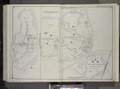 | 6,712 × 4,980 (95.63 MB) | Fæ | GWToolset: Creating mediafile for Fæ. Tranche 3 3501-5495 (repairs) @ 4 May 2014, 10:46 BST |
File usage
No pages on the English Wikipedia use this file (pages on other projects are not listed).
Global file usage
The following other wikis use this file:
- Usage on af.wikipedia.org