
File:Windy Fire smoke satellite view.jpg
No higher resolution available.
Windy_Fire_smoke_satellite_view.jpg (720 × 480 pixels, file size: 82 KB, MIME type: image/jpeg)
| This is a file from the Wikimedia Commons. Information from its description page there is shown below. Commons is a freely licensed media file repository. You can help. |
Summary
| Description |
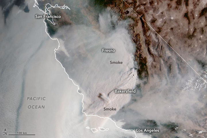
English: Original caption: "NASA satellites first detected signs of the KNP fire complex and the Windy fire within Sequoia National Park and the Tule River Reservation on September 10, 2021. Two weeks later, the lightning-triggered and wind-fueled blazes have spread and grown more intense, threatening groves of giant sequoias and prompting authorities to issue evacuation orders.
On the morning of September 24, 2021, the Geostationary Operational Environmental Satellite 17 (GOES-17) captured this natural-color image of vast plumes of smoke streaming from the fires and smothering Southern California." NASA Earth Observatory image by Joshua Stevens, using GOES 17 imagery courtesy of NOAA and the National Environmental Satellite, Data, and Information Service (NESDIS). Caption by Adam Voiland. |
| Date | |
| Source | https://earthobservatory.nasa.gov/images/148878/southern-california-under-smoke |
| Author | Joshua Stevens |
Licensing
| This file is in the public domain in the United States because it was solely created by NASA. NASA copyright policy states that "NASA material is not protected by copyright unless noted". (See Template:PD-USGov, NASA copyright policy page or JPL Image Use Policy.) | ||
 |
Warnings:
|
File history
Click on a date/time to view the file as it appeared at that time.
| Date/Time | Thumbnail | Dimensions | User | Comment | |
|---|---|---|---|---|---|
| current | 05:25, 3 January 2023 | | 720 × 480 (82 KB) | Penitentes | Uploaded a work by Joshua Stevens from https://earthobservatory.nasa.gov/images/148878/southern-california-under-smoke with UploadWizard |
File usage
The following pages on the English Wikipedia use this file (pages on other projects are not listed):