
File:Royal Bournemouth Hospital - geograph.org.uk - 64197.jpg
No higher resolution available.
Royal_Bournemouth_Hospital_-_geograph.org.uk_-_64197.jpg (640 × 357 pixels, file size: 100 KB, MIME type: image/jpeg)
| This is a file from the Wikimedia Commons. Information from its description page there is shown below. Commons is a freely licensed media file repository. You can help. |
Summary
| Description |
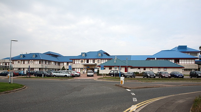
English: Royal Bournemouth Hospital. This is a large modern district general hospital with a distinctive blue roof on an out of town site. It covers a larger area than the photo shows. It replaced the Royal Victoria Hospital, Boscombe, (where my father worked up to 1968) which was demolished and turned into a supermarket.
Looking across a roundabout on Deansleigh Road. This is not the main entrance to the hospital for patients. |
| Date | |
| Source | From geograph.org.uk |
| Author | Peter Facey |
| Attribution (required by the license) | Peter Facey / Royal Bournemouth Hospital / |
| Camera location | | View this and other nearby images on: OpenStreetMap |
|---|
_heading:292.00&language=en)
| Object location | | View this and other nearby images on: OpenStreetMap |
|---|
_heading:292.00&language=en)
Licensing

|
This image was taken from the Geograph project collection. See this photograph's page on the Geograph website for the photographer's contact details. The copyright on this image is owned by Peter Facey and is licensed for reuse under the Creative Commons Attribution-ShareAlike 2.0 license.
|
This file is licensed under the Creative Commons Attribution-Share Alike 2.0 Generic license.
Attribution: Peter Facey
- You are free:
- to share – to copy, distribute and transmit the work
- to remix – to adapt the work
- Under the following conditions:
- attribution – You must give appropriate credit, provide a link to the license, and indicate if changes were made. You may do so in any reasonable manner, but not in any way that suggests the licensor endorses you or your use.
- share alike – If you remix, transform, or build upon the material, you must distribute your contributions under the same or compatible license as the original.
File history
Click on a date/time to view the file as it appeared at that time.
| Date/Time | Thumbnail | Dimensions | User | Comment | |
|---|---|---|---|---|---|
| current | 18:30, 30 January 2010 | | 640 × 357 (100 KB) | GeographBot | == {{int:filedesc}} == {{Information |description={{en|1=Royal Bournemouth Hospital. This is a large modern district general hospital with a distinctive blue roof on an out of town site. It covers a larger area than the photo shows. It replaced the Royal |
File usage
The following pages on the English Wikipedia use this file (pages on other projects are not listed):
Global file usage
The following other wikis use this file:
- Usage on fr.wikivoyage.org
- Usage on www.wikidata.org