
File:English kingdoms.svg

Size of this PNG preview of this SVG file: 481 × 599 pixels. Other resolutions: 192 × 240 pixels | 385 × 480 pixels | 616 × 768 pixels | 822 × 1,024 pixels | 1,643 × 2,048 pixels | 678 × 845 pixels.
Original file (SVG file, nominally 678 × 845 pixels, file size: 434 KB)
| This is a file from the Wikimedia Commons. Information from its description page there is shown below. Commons is a freely licensed media file repository. You can help. |
Summary
| Description |
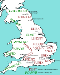
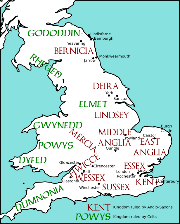
English: Map of England and Wales, showing Anglo-Saxon and Celtic kingdoms as of c. 600.
Redrawn from a map in James Campbell, The Anglo-Saxons, Penguin Books, 1991. |
||
| Date | 26 June 2007 (original upload date) | ||
| Source | The file was created using DMIS. On that site it is stated that "We do not claim copyright on the images, so you can use them for Wikipedia." | ||
| Author | Mike Christie at English Wikipedia | ||
| Permission (Reusing this file) |
|
||
| Other versions | File:English kingdoms 600.png, File:English kingdoms 600.gif |
Original upload log
Transferred from en.wikipedia to Commons by NuclearWarfare using CommonsHelper.
The original description page was here. All following user names refer to en.wikipedia.
- 2007-06-26 01:36 Mike Christie 651×897× (285282 bytes) Map of England and Wales, showing Anglo-Saxon and Celtic kingdoms as of c. 600. The file was created using [http://www.demis.nl/home/pages/home.htm DMIS]. On that site it is [http://support.demis.nl/forums/thread/1295.aspx stated] that "We do not claim
Licensing
| I, the copyright holder of this work, release this work into the public domain. This applies worldwide. In some countries this may not be legally possible; if so: I grant anyone the right to use this work for any purpose, without any conditions, unless such conditions are required by law. |
File history
Click on a date/time to view the file as it appeared at that time.
| Date/Time | Thumbnail | Dimensions | User | Comment | |
|---|---|---|---|---|---|
| current | 02:04, 31 December 2010 | | 678 × 845 (434 KB) | AnonMoos | margins, land should not be transparent |
| 22:39, 26 May 2010 |  | 689 × 905 (441 KB) | Marnanel | {{Information |Description={{en|1={{svg|map}} {{Information |Description={{en|Map of England and Wales, showing Anglo-Saxon and Celtic kingdoms as of c. 600. Redrawn from a map in James Campbell, ''The Anglo-Saxons'', Penguin Books, 1991.}} |Source=Tran |
File usage
The following pages on the English Wikipedia use this file (pages on other projects are not listed):
Global file usage
The following other wikis use this file:
- Usage on cs.wikipedia.org
- Usage on de.wikipedia.org
- Usage on it.wikipedia.org
- Discussione:Adda di Bernicia
- Discussione:Aethelric di Bernicia
- Discussione:Glappa di Bernicia
- Discussione:Cearl di Mercia
- Discussione:Ceawlin dei Gewisse
- Discussione:Ceol dei Gewisse
- Discussione:Ceolwulf dei Gewisse
- Discussione:Eowa
- Discussione:Etelrico di Deira
- Discussione:Hussa di Bernicia
- Discussione:Theodric di Bernicia
- Usage on nl.wikipedia.org
- Usage on pl.wikipedia.org