
File:AONB within Cornwall map.svg

Size of this PNG preview of this SVG file: 618 × 599 pixels. Other resolutions: 247 × 240 pixels | 495 × 480 pixels | 792 × 768 pixels | 1,056 × 1,024 pixels | 2,112 × 2,048 pixels | 1,224 × 1,187 pixels.
Original file (SVG file, nominally 1,224 × 1,187 pixels, file size: 1.36 MB)
| This is a file from the Wikimedia Commons. Information from its description page there is shown below. Commons is a freely licensed media file repository. You can help. |
| Description |
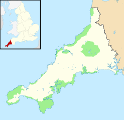
Map showing the Cornwall AONB within Cornwall Equirectangular map projection on WGS 84 datum, with N/S stretched 150% Geographic limits:
|
| Date | |
| Source |
|
| Author | Nilfanion, using Ordnance Survey and Natural England data |
| Permission (Reusing this file) |
This file is licensed under the Creative Commons Attribution-Share Alike 3.0 Unported license. Attribution: © Natural England copyright 2012. Contains Ordnance Survey data © Crown copyright and database right 2012
|
File history
Click on a date/time to view the file as it appeared at that time.
| Date/Time | Thumbnail | Dimensions | User | Comment | |
|---|---|---|---|---|---|
| current | 21:51, 12 May 2012 | | 1,224 × 1,187 (1.36 MB) | Nilfanion | {{Information |Description=Map showing the Cornwall AONB within Cornwall Equirectangular map projection on WGS 84 datum, with N/S stretched 150% Geographic limits: *West: 5.8W *East: 4.1W *North: 51.0N *South: 49.9N *South: 52.94N |Source=[[w:Ordnanc... |
File usage
The following pages on the English Wikipedia use this file (pages on other projects are not listed):
Global file usage
The following other wikis use this file:
- Usage on de.wikivoyage.org